Wildgerlostal
Krimml, Wald im Pinzgau
Peaks and crossings
- Wildgerlosspitze (3.289 m)
- Reichenspitze (3.303 m)
- Roßkopf (2.845 m)
- Gabler (3.263 m)
- Wildkarspitze (3.073 m)
- Rainbachscharte (2.724 m) to the Krimmler Tauernhaus (1.631 m)
- Rosskarscharte (2.689 m) to the Richter Hütte
Hard and soft rocks

Hard and soft rocks
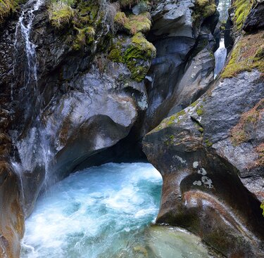
The Wildgerlosbach stream – s powerful glacier stream – created the beautiful Leitenkammer Gorge with its magnificent potholes and eroded shapes. Here the stream cuts through the hard core gneiss of the Venediger massif before flowing into what is today the Durlassboden reservoir 100 m below, located on the soft bedrock of the penninic basement. Dippers and grey wagtails can be frequently seen in this area. This gorge is home to alpine currants, species of saxifrage and a rich moss and fern flora.
One of the largest lakes in the National Park
The Lower Gerlossee at 2,328 m above sea level is ten hectares large and 39 metres deep. Water pipits and marmots can be observed in its environs. The surrounding boulder fields are covered with map lichen and dwarf willow. In-between we can find alpine sedge. Upper Gerlossee has a beautiful silting zone with white cottongrass and moss.
Glacial treasures of shape
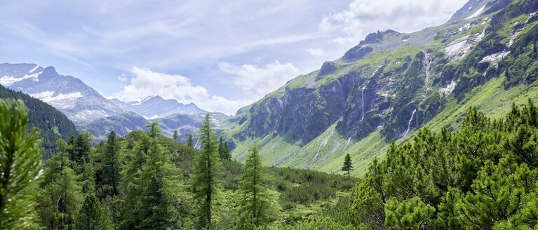
The Wildgerlostal brilliantly illustrates how the landscape was shaped by ice-age glaciers. It is a typical glacial trough. Here the glacier once scraped through the V-shaped valley to form its U-shape as seen today. The glacier and the weathering created cirques in which beautiful alpine lakes - such as the Gerlos Lakes - were formed after the ice had melted away. The last major glacial advance of the post-glacial period took place from 1850-1855. The "1850-moraine", deposited rubble and rocks, bears witness to this and appears particularly beautiful if watched before the receding Wildgerloskees glacier.es.
Leitenkammer Gorge

Leitenkammer Gorge
From Finkau Inn it's a ½ hour walk through Fichtenwald to the gorge. Viewing platforms provide easy access. Dippers and grey wagtails can be observed in the magnificent eroded potholes. After an escarpment south of Trisslalm hut, the prominent glacial trough of Wildgerlostal Valley opens up before you. Continue into the valley or via the Leitenkammer trail to the Breitscharte wind gap, the Plattenkogel (2,039 m, natural landmark) and to Krimml.
Walking time: from Finkau approx. 1 hour to Trisslalm hut
Wild and romantic – to Zittauer cottage
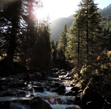
This easy valley walk becomes steep and alpine in the last section. The unspoilt population of Swiss pine along the mountainsides reaches up to around 2,000 m altitude. Then the craggy cliffs of the trough walls and rocks from rockfalls lend the valley its wild and romantic flair. The glacier stream has room and flows largely untouched. The receding glacier at the end of the valley left behind an impressive terminal moraine from the year 1850. It is through this moraine landscape that the last climb up to Gerlos lake leads.
Walking time: approx. 3 hours
High alpine – Rainbachtal to Krimmler Achental
From the Zittauer Hütte further on to the Oberer Gerlossee, a high-alpine, somewhat exposed but secured trail leads over the Rainbachscharte into the Rainbachtal and further into the Krimmler Achental. On the ascent you will find glacier buttercups, sticky primrose and small soldanelle. Marmots can be heard or seen. The view of the three-thousand-metre peaks and glaciers from the Scharte is breathtaking. The descent from the Scharte is secured at the beginning with ropes and ladders. Caution: in spring the safety ropes are still hidden under the snow. Continue to the Rainbachsee lake (2,404 m) with a beautiful siltation zone and cotton grass, through crested sedge meadows, dwarf shrub heath to abandoned alpine pastures and through mountain pines and Swiss stone pine forest to the Rainbachtal valley. The trail leads over the steep step down to the Krimmler Tauernhaus.
Walking time: approx. 4 hours
Durlassboden - Reservoir
The spring-fresh water of the Durlassboden reservoir reaches a pleasant 21 degrees in the summer months. There is a wide range of activities on offer: from surfing to swimming, kayaking or pedal boating. Austria's highest surfing school (1,400 m above sea level) is located at the Durlassboden reservoir. The jetty is located directly on the dam crest of the reservoir near the "Seestüberl" restaurant.
Hiking tip: The circular hike around the reservoir with refreshments at Gasthof Finkau, Bärschlagalm and Seestüberl on the dam crest..


